(Adding categories) |
No edit summary Tag: sourceedit |
||
| (5 intermediate revisions by 2 users not shown) | |||
| Line 18: | Line 18: | ||
|Row 7 info = [[Charles Bumginney]] |
|Row 7 info = [[Charles Bumginney]] |
||
}} |
}} |
||
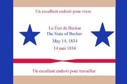
| + | [[File:Flag of Beckar 2016.jpg | thumb | 250px | The flag of Beckar since January 1, 2015 | link=Flag of Beckar ]] |
||
| − | |||
| − | '''Beckar''' is a state in the nation of [[Dragoonasag]]. |
+ | '''Beckar''' is a state in the nation of [[Dragoonasag]]. It was named after Zonapath Brimm Beckar, who fought in the Dragoonasag Revolution. Beckar's state flower is the Beckar rose; its state bird is the Beckar doughalia, and its state tree is the Beckar oak. |
==Geography== |
==Geography== |
||
| − | It is bordered by [[Lohana]] to the north, [[Cartana]] and [[Clarkania]] to the east, [[Varconia]] and [[Zayna]] to the south, and [[Garna]] to the west. |
+ | It is bordered by [[Lohana]] to the north, [[Cartana]] and [[Clarkania]] to the east, [[Varconia]] and [[Zayna]] to the south, and [[Garna]] to the west. Its three largest cities are [[Balkerton]], [[Hackard]], and [[Toughstown]]. |
| + | |||
| + | Beckar has four main geographical regions. The Jaspergreen Mountains region is located in northwestern Beckar. The Central and Southwestern Plains region occupies central Beckar, and includes all three of the state's large cities. The Southeast Mountains and Hills region is located in the southeastern part of the state, and northeastern Beckar is located in the Northeastern Mountain region. |
||
| + | |||
| + | ==History== |
||
| + | |||
| + | ===Before statehood=== |
||
| + | |||
| + | The region now known as Beckar was first settled by English-speaking settlers in the early 1800s. The area was occupied by native Parkufo groups before then; the natives have been inhabiting the land since the 1300s. The first English-speaking settler to arrive in the area was Charles Frouth Beckar, son of Dragoonasag Revolutionary War soldier Zonapath Brimm Beckar, who arrived around 1804. By the early 1820s, the region was settled by many English-speaking people. In 1824, city planners were asked to locate an ideal spot for the area's seat of government. They chose a little hill near a sacred Parkufo temple. In 1825, construction on the town that would come to be the city of Balkerton began. By the late 1820s, the city was considered a great place for the seat of government to be. Construction on a Government House (State House after Beckar's statehood) began. In 1833, the region applied for statehood, and, in 1834, became a Dragoonasag state, named Beckar, after a Dragoonasag Revolutionary War soldier. |
||
[[Category: Dragoonasag]] |
[[Category: Dragoonasag]] |
||
[[Category: Dragoonasag states]] |
[[Category: Dragoonasag states]] |
||
| − | [[Category:Beckar]] |
+ | [[Category:Beckar|*]] |
Latest revision as of 06:06, 2 June 2016
|
Beckar
| |
|
| |
|
Demonym(s)
|
Beckarian
|
|
Capital
|
Balkerton
|
|
Large cities
|
Balkerton
Hackard Toughstown |
|
Highest point
|
Mount Nettles[1]
|
|
Lowest point
|
Near Orick
|
|
Date of statehood
|
May 14, 1834
|
|
Governor
|
Charles Bumginney
|
The flag of Beckar since January 1, 2015
Beckar is a state in the nation of Dragoonasag. It was named after Zonapath Brimm Beckar, who fought in the Dragoonasag Revolution. Beckar's state flower is the Beckar rose; its state bird is the Beckar doughalia, and its state tree is the Beckar oak.
Geography[]
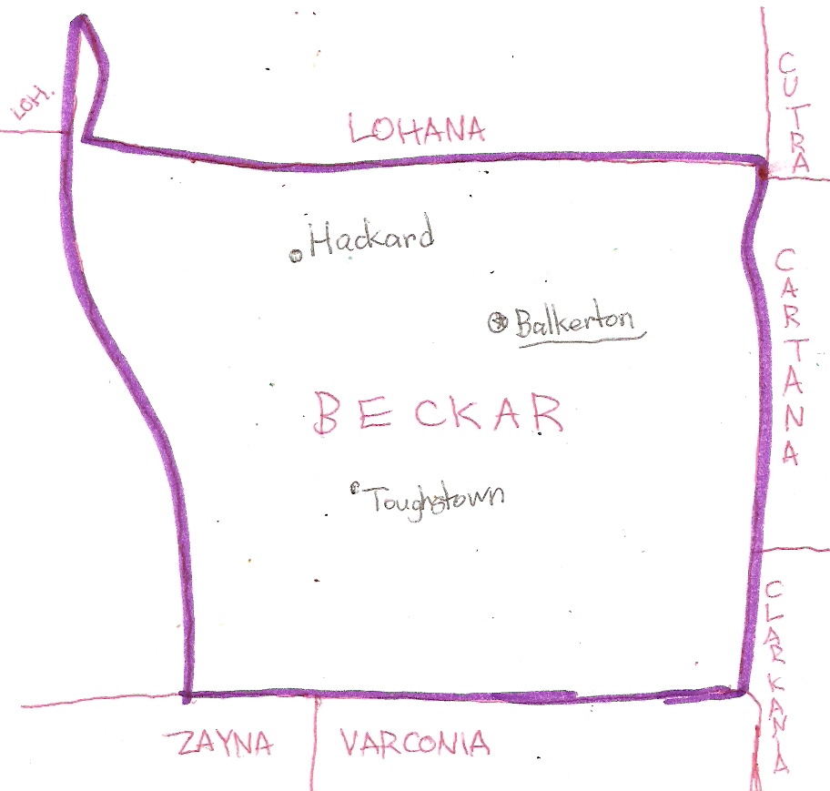
It is bordered by Lohana to the north, Cartana and Clarkania to the east, Varconia and Zayna to the south, and Garna to the west. Its three largest cities are Balkerton, Hackard, and Toughstown.
Beckar has four main geographical regions. The Jaspergreen Mountains region is located in northwestern Beckar. The Central and Southwestern Plains region occupies central Beckar, and includes all three of the state's large cities. The Southeast Mountains and Hills region is located in the southeastern part of the state, and northeastern Beckar is located in the Northeastern Mountain region.
History[]
Before statehood[]
The region now known as Beckar was first settled by English-speaking settlers in the early 1800s. The area was occupied by native Parkufo groups before then; the natives have been inhabiting the land since the 1300s. The first English-speaking settler to arrive in the area was Charles Frouth Beckar, son of Dragoonasag Revolutionary War soldier Zonapath Brimm Beckar, who arrived around 1804. By the early 1820s, the region was settled by many English-speaking people. In 1824, city planners were asked to locate an ideal spot for the area's seat of government. They chose a little hill near a sacred Parkufo temple. In 1825, construction on the town that would come to be the city of Balkerton began. By the late 1820s, the city was considered a great place for the seat of government to be. Construction on a Government House (State House after Beckar's statehood) began. In 1833, the region applied for statehood, and, in 1834, became a Dragoonasag state, named Beckar, after a Dragoonasag Revolutionary War soldier.
- ↑ List of highest points in Dragoonasag states